
Portal:World
The World Portal


The world is the totality of entities, the whole of reality, or everything that exists. The nature of the world has been conceptualized differently in different fields. Some conceptions see the world as unique while others talk of a "plurality of worlds". Some treat the world as one simple object while others analyze the world as a complex made up of parts.
In scientific cosmology, the world or universe is commonly defined as "[t]he totality of all space and time; all that is, has been, and will be". Theories of modality talk of possible worlds as complete and consistent ways how things could have been. Phenomenology, starting from the horizon of co-given objects present in the periphery of every experience, defines the world as the biggest horizon or the "horizon of all horizons". In philosophy of mind, the world is contrasted with the mind as that which is represented by the mind. Theology conceptualizes the world in relation to God, for example, as God's creation, as identical to God or as the two being interdependent. In religions, there is a tendency to downgrade the material or sensory world in favor of a spiritual world to be sought through religious practice. A comprehensive representation of the world and our place in it, as is found in religions, is known as a worldview. Cosmogony is the field that studies the origin or creation of the world while eschatology refers to the science or doctrine of the last things or of the end of the world.
In various contexts, the term "world" takes a more restricted meaning associated, for example, with the Earth and all life on it, with humanity as a whole or with an international or intercontinental scope. In this sense, world history refers to the history of humanity as a whole and world politics is the discipline of political science studying issues that transcend nations and continents. Other examples include terms such as "world religion", "world language", "world government", "world war", "world population", "world economy", or "world championship". (Full article...)
Selected articles -
-
 Superpower describes a state or supranational union that holds a dominant position characterized by the ability to exert influence or project power on a global scale. This is done through the combined means of economic, military, technological, political, and cultural strength as well as diplomatic and soft power influence. Traditionally, superpowers are preeminent among the great powers. While a great power state is capable of exerting its influence globally, superpowers are states so influential that no significant action can be taken by the global community without first considering the positions of the superpowers on the issue.
In 1944, during World War II, the term was first applied to the United States, the British Empire, and the Soviet Union. During the Cold War, the British Empire dissolved, leaving the United States and the Soviet Union to dominate world affairs. At the end of the Cold War and the dissolution of the Soviet Union in 1991, the United States became, and remains, the world's sole superpower, a position sometimes referred to as that of a "hyperpower". Since the late 2010s and into the 2020s, China has been described as a new superpower, as China poses "the most significant challenge of any nation-state in the world to the United States". (Full article...) -

Gerardus Mercator 1512–1594
The Mercator world map of 1569 is titled Nova et Aucta Orbis Terrae Descriptio ad Usum Navigantium Emendate Accommodata (Renaissance Latin for "New and more complete representation of the terrestrial globe properly adapted for use in navigation"). The title shows that Gerardus Mercator aimed to present contemporary knowledge of the geography of the world and at the same time 'correct' the chart to be more useful to sailors. This 'correction', whereby constant bearing sailing courses on the sphere (rhumb lines) are mapped to straight lines on the plane map, characterizes the Mercator projection. While the map's geography has been superseded by modern knowledge, its projection proved to be one of the most significant advances in the history of cartography, inspiring the 19th century map historian Adolf Nordenskiöld to write "The master of Rupelmonde stands unsurpassed in the history of cartography since the time of Ptolemy." The projection heralded a new era in the evolution of navigation maps and charts and it is still their basis.The map is inscribed with a great deal of text. The framed map legends (or cartouches) cover a wide variety of topics: a dedication to his patron and a copyright statement; discussions of rhumb lines; great circles and distances; comments on some of the major rivers; accounts of fictitious geography of the north pole and the southern continent. The full Latin texts and English translations of all the legends are given below. Other minor texts are sprinkled about the map. They cover such topics as the magnetic poles, the prime meridian, navigational features, minor geographical details, the voyages of discovery and myths of giants and cannibals. These minor texts are also given below. (Full article...) -

Global Peace Index 2023. Countries appearing with a deeper shade of green are ranked as more peaceful, countries appearing more red are ranked as more violent.
Global Peace Index (GPI) is a report produced by the Institute for Economics & Peace (IEP) which measures the relative position of nations' and regions' peacefulness. The GPI ranks 163 independent states and territories (collectively accounting for 99.7 per cent of the world's population) according to their levels of peacefulness. In the past decade, the GPI has presented trends of increased global violence and less peacefulness.
The GPI is developed in consultation with an international panel of peace experts from peace institutes and think tanks with data collected and collated by the Economist Intelligence Unit. The Index was first launched in May 2009, with subsequent reports being released annually. In 2015 it ranked 165 countries, up from 121 in 2007. The study was conceived by Australian technology entrepreneur Steve Killelea, and is endorsed by individuals such as former UN Secretary-General Kofi Annan, the Dalai Lama, archbishop Desmond Tutu, former President of Finland and 2008 Nobel Peace Prize laureate Martti Ahtisaari, Nobel laureate Muhammad Yunus, economist Jeffrey Sachs, former president of Ireland Mary Robinson, former Deputy Secretary-General of the United Nations Jan Eliasson and former United States president Jimmy Carter. The updated index is released each year at events in London, Washington, DC, and at the United Nations Secretariat in New York. (Full article...) -
The 2030 Agenda for Sustainable Development, adopted by all United Nations members in 2015, created 17 world Sustainable Development Goals (SDGs). They were created with the aim of "peace and prosperity for people and the planet..." – while tackling climate change and working to preserve oceans and forests. The SDGs highlight the connections between the environmental, social and economic aspects of sustainable development. Sustainability is at the center of the SDGs.
The short titles of the 17 SDGs are: No poverty (SDG 1), Zero hunger (SDG 2), Good health and well-being (SDG 3), Quality education (SDG 4), Gender equality (SDG 5), Clean water and sanitation (SDG 6), Affordable and clean energy (SDG 7), Decent work and economic growth (SDG 8), Industry, innovation and infrastructure (SDG 9), Reduced inequalities (SDG 10), Sustainable cities and communities (SDG 11), Responsible consumption and production (SDG 12), Climate action (SDG 13), Life below water (SDG 14), Life on land (SDG 15), Peace, justice, and strong institutions (SDG 16), and Partnerships for the goals (SDG 17). (Full article...) -

Laws concerning gender identity-expression by country or territory Legal identity change, surgery requiredNo legal identity changeUnknown/Ambiguous
Rights affecting lesbian, gay, bisexual, and transgender (LGBT) people vary greatly by country or jurisdiction—encompassing everything from the legal recognition of same-sex marriage to the death penalty for homosexuality.
Notably, , 36 countries recognize same-sex marriage. By contrast, not counting non-state actors and extrajudicial killings, only two countries are believed to impose the death penalty on consensual same-sex sexual acts: Iran and Afghanistan. The death penalty is officially law, but generally not practiced, in Mauritania, Saudi Arabia, Somalia (in the autonomous state of Jubaland) and the United Arab Emirates. LGBT people also face extrajudicial killings in the Russian region of Chechnya. Sudan rescinded its unenforced death penalty for anal sex (hetero- or homosexual) in 2020. Fifteen countries have stoning on the books as a penalty for adultery, which (in light of the illegality of gay marriage in those countries) would by default include gay sex, but this is enforced by the legal authorities in Iran and Nigeria (in the northern third of the country). (Full article...) -
Human symbolic expression developed as prehistoric humans reached behavioral modernity.
Culture (/ˈkʌltʃər/ KUL-chər) is a concept that encompasses the social behavior, institutions, and norms found in human societies, as well as the knowledge, beliefs, arts, laws, customs, capabilities, and habits of the individuals in these groups. Culture is often originated from or attributed to a specific region or location.
Humans acquire culture through the learning processes of enculturation and socialization, which is shown by the diversity of cultures across societies. (Full article...) -
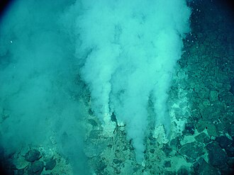
Evidence of possibly the oldest forms of life on Earth has been found in hydrothermal vent precipitates.
The earliest known life forms on Earth may be as old as 4.1 billion years old (or Ga) according to biologically fractionated graphite inside a single zircon grain in the Jack Hills range of Australia. The earliest evidence of life found in a stratigraphic unit, not just a single mineral grain, is the 3.7 Ga metasedimentary rocks containing graphite from the Isua Supracrustal Belt in Greenland. The earliest direct known life on land may be stromatolites which have been found in 3.480-billion-year-old geyserite uncovered in the Dresser Formation of the Pilbara Craton of Western Australia. Various microfossils of microorganisms have been found in 3.4 Ga rocks, including 3.465-billion-year-old Apex chert rocks from the same Australian craton region, and in 3.42 Ga hydrothermal vent precipitates from Barberton, South Africa. Much later in the geologic record, likely starting in 1.73 Ga, preserved molecular compounds of biologic origin are indicative of aerobic life. Therefore, the earliest time for the origin of life on Earth is at least 3.5 billion years ago, possibly as early as 4.1 billion years ago — not long after the oceans formed 4.5 billion years ago and after the formation of the Earth 4.54 billion years ago. (Full article...)


General images -
-

-
 Lithified stromatolites on the shores of Lake Thetis, Western Australia. Archean stromatolites are the first direct fossil traces of life on Earth. (from History of Earth)
 -

-
 An artist's impression of the Archean, the eon after Earth's formation, featuring round stromatolites, which are early oxygen-producing forms of life from billions of years ago. After the Late Heavy Bombardment, Earth's crust had cooled, its water-rich barren surface is marked by continents and volcanoes, with the Moon still orbiting Earth half as far as it is today, appearing 2.8 times larger and producing strong tides. (from Earth)
 -
 An animation of the changing density of productive vegetation on land (low in brown; heavy in dark green) and phytoplankton at the ocean surface (low in purple; high in yellow) (from Earth)
 -
 Japanese depiction of a Portuguese carrack. European maritime innovations led to proto-globalization.
 -
 Last Moon landing: Apollo 17 (1972)
 -

-
 A view of Earth with different layers of its atmosphere visible: the troposphere with its clouds casting shadows, a band of stratospheric blue sky at the horizon, and a line of green airglow of the lower thermosphere around an altitude of 100 km, at the edge of space (from Earth)
 -
 Trilobites first appeared during the Cambrian period and were among the most widespread and diverse groups of Paleozoic organisms. (from History of Earth)
 -
 Machu Picchu, Inca Empire, Peru
 -
Artist's impression of Earth during the later Archean, the largely cooled planetary crust and water-rich barren surface, marked by volcanoes and continents, features already round microbialites. The Moon, still orbiting Earth much closer than today and still dominating Earth's sky, produced strong tides. (from History of Earth)
-
 The Pantheon, originally a Roman temple, now a Catholic church
 -
 Earth's land use for human agriculture in 2019 (from Earth)
 -

-

-
 A view of Earth with its global ocean and cloud cover, which dominate Earth's surface and hydrosphere; at Earth's polar regions, its hydrosphere forms larger areas of ice cover. (from Earth)
 -
 Artist's rendition of an oxinated fully-frozen Snowball Earth with no remaining liquid surface water. (from History of Earth)
 -

-
 Image of the physical world, captured by the Hubble Space Telescope (from World)
 -

-
 Taj Mahal, Mughal Empire, India
 -
 Cross-section through a liposome (from History of Earth)
 -

-
 Notre-Dame de Paris, France
 -
 Chloroplasts in the cells of a moss (from History of Earth)
 -

-
 Graph showing range of estimated partial pressure of atmospheric oxygen through geologic time (from History of Earth)
 -

-

-
 Geologic map of North America, color-coded by age. From most recent to oldest, age is indicated by yellow, green, blue, and red. The reds and pinks indicate rock from the Archean.
 -
 Earth's western hemisphere showing topography relative to Earth's center instead of to mean sea level, as in common topographic maps (from Earth)
 -
 Great Pyramids of Giza, Egypt
 -
 A computer-generated image mapping the prevalence of artificial satellites and space debris around Earth in geosynchronous and low Earth orbit (from Earth)
 -
 Persepolis, Achaemenid Empire, 6th century BCE
 -
 Artist's impression of the enormous collision that probably formed the Moon (from History of Earth)
 -
 Ajloun Castle, Jordan
 -
 Battle during 1281 Mongol invasion of Japan
 -
 A map of heat flow from Earth's interior to the surface of Earth's crust, mostly along the oceanic ridges (from Earth)
 -
 The replicator in virtually all known life is deoxyribonucleic acid. DNA is far more complex than the original replicator and its replication systems are highly elaborate. (from History of Earth)
 -

-
 Pale orange dot, an artist's impression of Early Earth, featuring its tinted orange methane-rich early atmosphere (from Earth)
 -
 Standing Buddha from Gandhara, 2nd century CE
 -
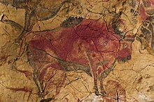
 A 580 million year old fossil of Spriggina floundensi, an animal from the Ediacaran period. Such life forms could have been ancestors to the many new forms that originated in the Cambrian Explosion. (from History of Earth)
 -

-
 A pillar at Göbekli Tepe
 -
 A composite image of artificial light emissions at night on a map of Earth (from Earth)
 -
 Map of peopling of the world (Southern Dispersal paradigm), in thousands of years ago.
 -

-
 Satellite time lapse imagery of Earth's rotation showing axis tilt (from Earth)
 -

-
 An artist's impression of ice age Earth at glacial maximum. (from History of Earth)
 -
 Tiktaalik, a fish with limb-like fins and a predecessor of tetrapods. Reconstruction from fossils about 375 million years old. (from History of Earth)
 -

-
 Olmec colossal head, now at the Museo de Antropología de Xalapa
 -
 Artist's conception of Hadean Eon Earth, when it was much hotter and inhospitable to all forms of life. (from History of Earth)
 -
 Tracy Caldwell Dyson, a NASA astronaut, observing Earth from the Cupola module at the International Space Station on 11 September 2010 (from Earth)
 -
 A schematic view of Earth's magnetosphere with solar wind flowing from left to right (from Earth)
 -
 Vitruvian Man by Leonardo da Vinci epitomizes the advances in art and science seen during the Renaissance. (from History of Earth)
 -
 Pangaea was a supercontinent that existed from about 300 to 180 Ma. The outlines of the modern continents and other landmasses are indicated on this map. (from History of Earth)
 -
 A reconstruction of Pannotia (550 Ma). (from History of Earth)
 -
 A 2012 artistic impression of the early Solar System's protoplanetary disk from which Earth and other Solar System bodies were formed (from Earth)
 -
 Dinosaurs were the dominant terrestrial vertebrates throughout most of the Mesozoic (from History of Earth)
 -
 Artist's conception of Devonian flora (from History of Earth)
 -

-
 Angkor Wat temple complex, Cambodia, early 12th century
 -
 "Lucy", the first Australopithecus afarensis skeleton found. Lucy was only 1.06 m (3 ft 6 in) tall.
 -
 Great Mosque of Kairouan, Tunisia, founded 670 CE
 -
 Chennakesava Temple, Belur, India
 -
 Shanghai. China urbanized rapidly in the 21st century.
 -

-
 Ming dynasty section, Great Wall of China
 -
 A reconstruction of human history based on fossil data. (from History of Earth)
 -
 A Benin Bronze head from Nigeria
 -
 Earth's night-side upper atmosphere appearing from the bottom as bands of afterglow illuminating the troposphere in orange with silhouettes of clouds, and the stratosphere in white and blue. Next the mesosphere (pink area) extends to the orange and faintly green line of the lowest airglow, at about one hundred kilometers at the edge of space and the lower edge of the thermosphere (invisible). Continuing with green and red bands of aurorae stretching over several hundred kilometers. (from Earth)
 -
 View of Earth from the Moon by the Lunar Reconnaissance Orbiter (from Earth)
 -
 A banded iron formation from the 3.15 Ga Moodies Group, Barberton Greenstone Belt, South Africa. Red layers represent the times when oxygen was available; gray layers were formed in anoxic circumstances. (from History of Earth)
 -
 Fall of the Berlin Wall, 1989
 -
 Artist's impression of a Hadean landscape with the relatively newly formed Moon still looming closely over Earth and both bodies sustaining strong volcanism. (from History of Earth)
 -
 Obelisk of Axum, Ethiopia
 -
 Florence, birthplace of the Italian Renaissance
 -
The pale orange dot, an artist's impression of the early Earth which might have appeared orange through its hazy methane rich prebiotic second atmosphere. Earth's atmosphere at this stage was somewhat comparable to today's atmosphere of Titan. (from History of Earth)
-

-
 Earth's axial tilt causing different angles of seasonal illumination at different orbital positions around the Sun (from Earth)
 -
 First airplane, the Wright Flyer, flew on 17 December 1903.
 -
 Empires of the world in 1898
 -
 Change in average surface air temperature and drivers for that change. Human activity has caused increased temperatures, with natural forces adding some variability. (from Earth)
 -

-
 Yggdrasil, an attempt to reconstruct the Norse world tree which connects the heavens, the world, and the underworld. (from World)
 -
 An artist's rendering of a protoplanetary disk (from History of Earth)
 -
 Earth's history with time-spans of the eons to scale (from History of Earth)
 -
 A composite image of Earth, with its different types of surface discernible: Earth's surface dominating Ocean (blue), Africa with lush (green) to dry (brown) land and Earth's polar ice in the form of Antarctic sea ice (grey) covering the Antarctic or Southern Ocean and the Antarctic ice sheet (white) covering Antarctica. (from Earth)


.svg)


.jpeg)


.jpg)


.jpg)


.jpg)


Megacities of the world -

Rio de Janeiro (Portuguese: [ˈʁi.u d(ʒi) ʒɐˈne(j)ɾu] ), or simply Rio, is the capital of the state of Rio de Janeiro. It is the second-most-populous city in Brazil (after São Paulo) and the sixth-most-populous city in the Americas.
Founded in 1565 by the Portuguese, the city was initially the seat of the Captaincy of Rio de Janeiro, a domain of the Portuguese Empire. In 1763, it became the capital of the State of Brazil, a state of the Portuguese Empire. In 1808, when the Portuguese Royal Court moved to Brazil, Rio de Janeiro became the seat of the court of Queen Maria I of Portugal. She subsequently, under the leadership of her son the prince regent John VI of Portugal, raised Brazil to the dignity of a kingdom, within the United Kingdom of Portugal, Brazil, and Algarves. Rio remained as the capital of the pluricontinental monarchy until 1822, when the Brazilian War of Independence began. This is one of the few instances in history that the capital of a colonizing country officially shifted to a city in one of its colonies. Rio de Janeiro subsequently served as the capital of the independent monarchy, the Empire of Brazil, until 1889, and then the capital of a republican Brazil until 1960 when the capital was transferred to Brasília. (Full article...)Did you know -

- ... that agronomist Simon Groot was awarded the 2019 World Food Prize for "benefiting hundreds of millions of consumers with greater access to nutritious vegetables"?
- ... that the visual design of Overwatch character Widowmaker was inspired by World of Warcraft character Sylvanas Windrunner?
- ... that Hungarians Gyula Bajó and Endre Hevizi, who went on to design stained glass for the Debre Libanos monastery, worked as labourers in a British pottery after the Second World War?
- ... that the conductor Im Won-sik is considered the "father of Korea's classical music world"?
- ... that after being hijacked, United Airlines Flight 175 almost had two mid-air collisions with other aircraft before crashing into the South Tower of the World Trade Center?
- ... that Arti Rana was the president of the self-help group Tharu Hath KargaGharelu Udyog when it received assistance from the World Wide Fund for Nature to make its looms more efficient?
- ... that Called Up Sent Down: The Bevin Boys' War describes the experiences of young men conscripted to work as coal miners in Britain during World War II?
- ... that during the 1913 El Paso smelters' strike the Industrial Workers of the World and the Western Federation of Miners competed to organize the strikers with their respective labor unions?
Countries of the world -

El Salvador, officially the Republic of El Salvador, is a country in Central America. It is bordered on the northeast by Honduras, on the northwest by Guatemala, and on the south by the Pacific Ocean. El Salvador's capital and largest city is San Salvador. The country's population in 2023 was estimated to be 6.5 million.
Among the Mesoamerican nations that historically controlled the region are the Lenca (after 600 AD), the Mayans, and then the Cuzcatlecs. Archaeological monuments also suggest an early Olmec presence around the first millennium BC. In the beginning of the 16th century, the Spanish Empire conquered the Central American territory, incorporating it into the Viceroyalty of New Spain ruled from Mexico City. However the Viceroyalty of New Spain had little to no influence in the daily affairs of the isthmus, which was colonized in 1524. In 1609, the area was declared the Captaincy General of Guatemala by the Spanish, which included the territory that would become El Salvador until its independence from Spain in 1821. It was forcibly incorporated into the First Mexican Empire, then seceded, joining the Federal Republic of Central America in 1823. When the federation dissolved in 1841, El Salvador became a sovereign state, then formed a short-lived union with Honduras and Nicaragua called the Greater Republic of Central America, which lasted from 1895 to 1898. (Full article...)Related portals
Protected areas of the world -
-

Mombacho Volcano Natural Reserve
The protected areas of Nicaragua are areas that have natural beauty or significance and are protected by Nicaragua. Nicaragua has 78 protected areas that cover 22,422 km2, about 17.3% of the nations landmass. The National System of Protected Areas (SINAP) is administered by the Ministry of the Environment and Natural Resources (MARENA). (Full article...) -
The main protected areas of Croatia are national parks, nature parks and strict reserves. There are 444 protected areas of Croatia, encompassing 9% of the country. Those include 8 national parks in Croatia, 2 strict reserves and 11 nature parks. The most famous protected area and the oldest national park in Croatia is the Plitvice Lakes National Park, a UNESCO World Heritage Site. Velebit Nature Park is a part of the UNESCO Man and the Biosphere Programme. The strict and special reserves, as well as the national and nature parks, are managed and protected by the central government, while other protected areas are managed by counties. In 2005, the National Ecological Network was set up, as the first step in preparation of the EU accession and joining of the Natura 2000 network.
The total area of all national parks in the country is 994 km2 (384 sq mi), of which 235 km2 (91 sq mi) is sea surface. Each of the national parks is maintained by a separate institution, overseen and funded by the government ministry of nature conservation and spatial development. The State Institute for Nature Protection provides centralized oversight and expertise. (Full article...) -
Kentucky's system of 44 state parks has been referred to as "the nation's finest" and experiences more repeat business annually than those of any other U.S. state. The state's diverse geography provides a variety of environments to experience. From mountain lakes to expansive caves to forests teeming with wildlife, park-goers have their choice of attractions, and they are all within a day's drive of each other.
Unless otherwise specified, data in the following lists are taken from Kentucky State Parks by Bill Bailey. (Full article...) -
Protected areas of Canada consist of approximately 12.1 percent of the nation's landmass and freshwater are considered conservation areas, including 11.4 percent designated as protected areas. Approximately 13.8 percent of Canada's territorial waters are conserved, including 8.9 percent designated as protected areas. Terrestrial areas conserved have increased by 65 percent in the 21st century, while marine areas conserved have increased by more than 3,800 percent.
Conservation and protected areas have different mandates depending on the organization which manages them, with some areas having a greater focus on ecological integrity, historical preservation, public usage, scientific research, or a combination of usages. Some areas such as the Polar Bear Pass, are co-managed and overseen by government and local indigenous agencies. (Full article...) -

West Matukituki Valley and the Matukituki River seen from Cascade Saddle in Mount Aspiring National Park
Protected areas of New Zealand are areas that are in some way protected to preserve their environmental, scientific, scenic, historical, cultural or recreational value. There are about 10,000 protected areas, covering about a third of the country. The method and aims of protection vary according to the importance of the resource and whether it is publicly or privately owned.
Nearly 30 percent of New Zealand's land mass is publicly owned with some degree of protection. Most of this land – about 80,000 square kilometres (31,000 sq mi) – is administered by the Department of Conservation. There are 13 national parks, thousands of reserves, 54 conservation parks, and a range of other conservation areas. (Full article...) -
This is a list of protected areas of Saudi Arabia, some of which are managed by the Saudi Wildlife Authority.:
- At-Taysiyah Protected Area
- Jabal Shada Nature Reserve
- Majami'al-Hadb Protected Area
- Nafud al-'Urayq
- Raydah Natural Reserve
- 'Uruq Bani Ma'arid
- Saja Umm Ar-Rimth Natural Reserve
- Harrat al-Harrah Protected Area
- Al-Khunfah Natural Reserve
- Ibex Reserve Protected Area
- Mahazat as-Sayd Protected Area
- Umm al-Qamari Islands
- Al-Tubayq Natural Reserve
- Farasan Islands Protected Area
- Jubail Marine Wildlife Sanctuary
- Jabal Aja Protected Area
- Wadi Turabah Nature Reserve
-
This is a list of protected areas of Yukon. The Yukon, formerly called Yukon Territory and sometimes referred to as just Yukon is the smallest and westernmost of Canada's three territories. It also is the least populated province or territory in Canada, with a population of 35,874 people as of the 2016 Census. (Full article...) -
The Australian Capital Territory as of 2014 contains 46 separate protected areas with a total land area of 1,302 km2 (503 sq mi) or 55.5% of the territory's area, and which managed by Territory and Municipal Services of the ACT government: (Full article...)
-
-
Protected areas of Tamil Nadu cover an area of 3,305 km2 (1,276 sq mi), constituting 2.54% of the geographic area and 15% of the 22,643 km2 (8,743 sq mi) recorded forest area of the state of Tamil Nadu in South India. It ranks 14th among all the states and union territories of India in terms of total protected area.
Protected areas in South India were created from private hunting grounds of the erstwhile Maharajas of the princely states. Mudumalai National Park was established in 1940 and was the first modern wildlife sanctuary in South India. The protected areas are administered by the Ministry of Environment and Forests of Government of India and the Tamil Nadu Forest Department. (Full article...) -
Cadw is the historic environment service of the Welsh Government which manages historical buildings and ancient monuments in Wales. (Full article...)
-

A view of Kaptai National Park
This is a list of protected areas of Bangladesh. Bangladesh is a country in South Asia. It is the eighth-most populous country in the world, with a population exceeding 163 million people in an area of either 148,460 square kilometres (57,320 sq mi) or 147,570 square kilometres (56,980 sq mi), making it one of the most densely populated countries in the world. (Full article...) -
Protected areas of Indonesia comprise both terrestrial and marine environments in any of the six IUCN Protected Area categories. There are over 500 protected areas in Indonesia, of which 54 National Parks cover 16.4 million ha, and another 527 nature and game reserves cover a further 28.3 million ha. The total protected land area represents over 15% of Indonesia's landmass. Marine Protected Areas comprise over 15.7 million ha representing ca. 5% of territorial waters. (Full article...)
-
The northernmost tip of Prins Karls Forland in Forlandet National Park
Svalbard is an Arctic wilderness archipelago comprising the northernmost part of Norway. There are twenty-nine protected natural areas, consisting of seven national parks, six nature reserves, fifteen bird sanctuaries and one geotope protected area. In addition, human traces dating from before 1946 are automatically protected. The protected areas make up 39,800 square kilometers (15,400 sq mi) or 65% of the land area, and 78,000 square kilometers (30,000 sq mi) or 86.5% of the territorial waters. The largest protected areas are Nordaust-Svalbard Nature Reserve and Søraust-Svalbard Nature Reserve, which cover most of the areas east of the main island of Spitsbergen, including the islands of Nordaustlandet, Edgeøya, Barentsøya, Kong Karls Land and Kvitøya. Six of the national parks are located on Spitsbergen. Ten of the bird sanctuaries and the Moffen Nature Reserve are located within national parks. Five of the bird sanctuaries are Ramsar sites and fourteen of the bird sanctuaries are islands. Svalbard is on Norway's tentative list for nomination as a UNESCO World Heritage Site.
The supreme responsibility for conservation lies with the Norwegian Ministry of the Environment, which has delegated the management to the Governor of Svalbard and the Norwegian Directorate for Nature Management. The foundation for conservation was established in the Svalbard Treaty of 1920, and has been further specified in the Svalbard Environmental Act of 2001. The first round of protection took force on 1 July 1973, when most of the current protected areas came into effect. This included the two large nature reserves and three of the national parks. Moffen Nature Reserve was established in 1983, followed by four national parks, three nature reserves and one geotope protection area between 2002 and 2005. (Full article...) -

A family of Asiatic lions at Gir National Park
The Gujarat state of western India has four National Parks and twenty-three wildlife sanctuaries which are managed by the Forest Department of the Government of Gujarat. (Full article...)


Selected world maps
-
 A plate tectonics map with volcano locations indicated with red circles
 -
 1516 map of the world by Martin Waldseemüller
 -
 The Goode homolosine projection is a pseudocylindrical, equal-area, composite map projection used for world maps.
 -
 Mollweide projection of the world
 -
 The world map by Gerardus Mercator (1569), the first map in the well-known Mercator projection
 -
 Only a few of the largest large igneous provinces appear (coloured dark purple) on this geological map, which depicts crustal geologic provinces as seen in seismic refraction data
 -
 Index map from the International Map of the World (1:1,000,000 scale)
 -
 United Nations Human Development Index map by country (2016)
 -
 Time zones of the world


World records
- List of Olympic records in athletics
- List of world records in athletics
- List of junior world records in athletics
- List of world records in masters athletics
- List of world youth bests in athletics
- List of IPC world records in athletics
- List of world records in canoeing
- List of world records in chess
- List of cycling records
- List of world records in track cycling
- List of world records in finswimming
- List of world records in juggling
- List of world records in rowing
- List of world records in speed skating
- List of world records in swimming
- List of IPC world records in swimming
- List of world records in Olympic weightlifting
Topics

Continents of Earth | ||||||||
|---|---|---|---|---|---|---|---|---|
| ||||||||
| ||||||||
| ||||||||


| Cenozoic Era (present–66.0 Ma) |
| ||||||||||||
|---|---|---|---|---|---|---|---|---|---|---|---|---|---|
| Mesozoic Era (66.0–252 Ma) |
| ||||||||||||
| Paleozoic Era (252–539 Ma) |
| ||||||||||||
| Proterozoic Eon (539 Ma–2.5 Ga) |
| ||||||||||||
| Archean Eon (2.5–4 Ga) | |||||||||||||
| Hadean Eon (4–4.6 Ga) | |||||||||||||
ka = kiloannum (thousands years ago); Ma = megaannum (millions years ago); Ga = gigaannum (billions years ago). See also: Geologic time scale • | |||||||||||||
| Locations | ||
|---|---|---|
| Related | ||

| |||||||||||||||||||
| |||||||||||||||||||
| |||||||||||||||||||

Economic classification of countries | |||||
|---|---|---|---|---|---|
| Three-World Model | |||||
| Gross domestic product (GDP) |
| ||||
| Gross national income (GNI) | |||||
| Wages | |||||
| Wealth | |||||
| Other national accounts | |||||
| Human development | |||||
| Digital divide | |||||
| Net international investment position (NIIP) | |||||
| Technological |
| ||||
|---|---|---|---|---|---|
| Sociological | |||||
| Ecological |
| ||||
| Biological |
| ||||
| Astronomical | |||||
| Eschatological |
| ||||
| Others |
| ||||
| Fictional | |||||
| Organizations | |||||
Categories

Wikimedia
The following Wikimedia Foundation sister projects provide more on this subject:
-
 Commons
Free media repository -
 Wikibooks
Free textbooks and manuals -
 Wikidata
Free knowledge base -
 Wikinews
Free-content news -
 Wikiquote
Collection of quotations -
 Wikisource
Free-content library -
 Wikispecies
Directory of species -
 Wikiversity
Free learning tools -
 Wikivoyage
Free travel guide -
 Wiktionary
Dictionary and thesaurus


