
User:RandomInfinity17
Hello! I track tropical and subtropical cyclones around the world.
| This user participates in WikiProject Tropical cyclones. |
| This user participates in the Non-tropical storms task force. |
| This user likes tracking tropical cyclones. |
| This user is really fascinated by the weather. |
| This user is interested in severe weather. |
| This user is a participant in WikiProject Weather |
| This user's most intense tropical cyclone ever experienced was Hurricane Marie in 2014. |
Interesting weather and space images[edit]
-
 A possible subtropical cyclone in the Black Sea on September 27, 2005.
 -
 Radar scan of the 2021 Western Kentucky tornado lifting debris from the town of Mayfield 30,000 feet into the atmosphere.
 -
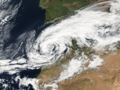
 Storm Dennis, the most intense European windstorm of the 21st century, on February 15, 2020.
 -

-
 Track of Tropical Storm Five of the 1952 Atlantic hurricane season, the northernmost forming Atlantic tropical cyclone.
 -
 A house that was wiped off its foundation after the extremely violent 2011 Hackleburg–Phil Campbell tornado.
 -

-
 Subtropical Cyclone Katie near Easter Island on May 2, 2015.
 -
 One of the first photos of the Andromeda Galaxy, taken in 1899 by Issac Roberts.
 -
 Image of the 1997 Jarrell tornado at peak intensity over the Double Creek Estates in Jarrell, Texas.
 -
 Satellite image of the 2022 Hunga Tonga–Hunga Haʻapai eruption and the extratropical remnants of Cyclone Cody.
 -
 Radar loop of the most prolific December tornado outbreak on record on December 15, 2021.
 -
 Cryovolcanoes spewing out ice at the south pole of Enceladus.
 -
 Hurricane Dorian approaching Canada as powerful extratropical cyclone on September 7, 2019.
 -
 An unrated landspout tornado near Marble, Colorado on May 29, 2021.
 -
 A record-breaking bomb cyclone off the coast of the Pacific Northwest on October 24, 2021.
 -
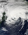
 Subtropical Storm One at peak intensity on January 16, 2023.
 -
 C/2022 E3 (ZTF), a long-period comet, on January 27, 2023.
 -
 A waterspout inside of Tropical Storm Colin on June 6, 2016.
 -
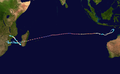 Track of Cyclone Freddy, the longest-lived tropical cyclone on record.
 -
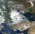
 A potential subtropical storm of the coast of Morroco on February 17, 2002.
 -
 The 1904, Moscow tornado, one of the deadliest Russian tornadoes on record.
 -
 2023 CX1 entering Earth's atmosphere over France on February 13, 2023.
 -
 Subtropical Storm Raoni off the coast of Argentina on June 28, 2021


.jpg)


-_Alessandro_Bianconi.jpg)


Tropical cyclones in 2023 (personal analysis)[edit]

Subpages[edit]
My Subpages:
Good ones/Actively working on[edit]
- My sandbox
- Effects of the 1982–83 El Niño in Peru†
- Tropical Storm Namtheun (2021)†
- Unusual areas of tropical cyclogensis†
- Potential Tropical Cyclone Four†
- F6
- 2023 Naypyidaw tornado†
- List of costliest tropical cyclones
Inactive[edit]
- Significant tornadoes of 2023
- Table of Central Pacific tropical cyclones†
- Deadliest tropical cyclones by basin
Mainspace[edit]
- List of costliest tropical cyclones
- Template:Table of F5 and EF5 tornadoes
- Weather of 1985
- October 2022 Southern Ocean cyclone
† open to editing from others
My best works[edit]
- Weather of 2023 (
 / Top ) – Started article and contributed significantly to it by adding weather events as they go
 - Template:10 deadliest tornadoes worldwide and Template:F5 and EF5 tornadoes (
 ) – Started them and my contributions are most of the template content
 - List of costliest tropical cyclones (
 / Low ) – Started article and most of the article is my contribution, had to delete "some" but I still have the original still exists here
 - Hurricane Hilary (2023) (
 / Mid ) – Started article
 - Weather of 1985 (
 / Low ) – Started article and added all events
 - October 2022 Southern Ocean cyclone (/ Mid ) – Created article
Random Tropical Cyclone ()[edit]

Severe Tropical Cyclone Zoe was the second-most intense tropical cyclone on record within the Southern Hemisphere and was the strongest tropical cyclone worldwide in 2002. The system was first noted on December 23, 2002, as a tropical depression that had developed, within the South Pacific Convergence Zone to the east of Tuvalu. Over the next couple of days, the system moved southwestwards and crossed the International Dateline early on December 25. After this, the system became better organized and was declared to be a tropical cyclone and named Zoe later that day. Zoe subsequently rapidly intensified in very favorable conditions as it continued to move west-southwest towards the Solomon Islands. The system subsequently became a Category 5 tropical cyclone on both the Australian tropical cyclone intensity scale and the Saffir-Simpson hurricane wind scale on December 27. The system subsequently affected the Solomon Islands Temotu Province during that day, before it peaked with 10-minute sustained wind speeds of 240 km/h (150 mph). As the system peaked, it performed a small clockwise cyclonic loop within the vicinity of Tikopia island, as a result of the steering flow over the cyclone becoming weak and variable. The system subsequently started to move towards the southeast during December 29, in response to a strengthening steering flow, provided by an upper level trough of low pressure and a baroclinic system near New Caledonia. Over the next few days the system weakened and degenerated into a tropical depression during January 1, 2003. The system was subsequently last noted during January 4, while it was located to the southeast of New Caledonia.
Cyclone Zoe severely affected areas of Rotuma, the Solomon Islands, and Vanuatu. Heavy rainfall and strong winds were particularly disastrous to the Solomon Islands, especially on the islands of Anuta and Tikopia. There, numerous crops and fruit–bearing trees were destroyed. Beaches were also heavily eroded due to the high waves generated by the cyclone. Although effects were lesser in Vanuatu, the country's northernmost islands experienced heavy flooding and beaches destroyed by high waves. After this usage of the name Zoe, the name was retired. (Full article...)